AIR
TRAFFIC RULES AND SERVICES (RAC)
INTRODUCTION
1.
RESPONSIBLE AUTHORITY
1.1
The authority responsible for the overall administration of air traffic services
provided for international civil aviation in the territory of Sri Lanka is the
Director of the Department of Civil Aviation acting under the authority of the
Ministry of Defense.
2.
AREA OF RESPONSIBILITY
2.1
Air Traffic Services as indicated in the following paragraphs are provided
within the Colombo FIR.
3.
AIR TRAFFIC SERVICES
3.1
With the exception of military aerodromes, Air Traffic Services in the Colombo
FIR are provided by the Air Traffic Services Division of the Airport and
Aviation Services (SL) Ltd. under the delegated authority of the Director of
Civil Aviation, Sri Lanka.
3.2
The airspace of the territory of Sri Lanka including adjacent waters comprises
the Colombo FIR (Sec. RAG 3-1.1). Air Traffic Control is exercised :
(a)
In the Colombo Terminal Control Area (TMA) ;
(b)
On Airways covering the main ATS routes and within control zones at controlled
aerodromes equipped with approach and landing aids.
3.3
Flight information service and alerting service within the Colombo FIR and air
traffic control services in control areas are provided by one Centre (ACC
Colombo~ . There is no distinction between upper and lower airspace. The axis of
each airway is constituted by a line connecting reference points identified
normally by radio navigational facilities.
3.4
Air traffic control and Alerting Services within Control Zones (listed in RAC
3-3.1) are provided by the Approach Control Unit or the Aerodrome Control Tower
serving the aerodrome.
3.4.1
Flight information service and alerting service within the FIR, air traffic
advisory service along ATS routes and air traffic control service in the Colombo
Terminal Ar6a (TMA) and along Airways are provided by the Colombo Area Control
Centre.
3.4.2
Flight information service. alerting service and air traffic advisory service
within Male FIR (excluding Male TMA) are provided by the Colombo Area Control
Centre.
3.5
Radar Service is an integral part of the ATS system. A description of radar
services and procedures is provided in part RAC 1. Additional procedures
applicable in Colombo -7-MA are contained in part RAC 4.
3.6
The description of the airspace designated for air traffic services purpose is
found in several tables, all forming part of RAC 3.
3.7
In general, air traffic rules and procedures in force and the organization of
air traffic services are in conformity with ICAO Standards, Recommended
Practices and Procedures. There are no outstanding differences between national
and international rules and procedures.
3.8
A few prohibited areas, restricted areas and danger areas are established within
Colombo FIR. These areas are shown in RAC 5. Activation of areas subject to
intermittent activity is notified well in advance by NOTAM, giving reference to
the area only by its identification.
4.CO-ORDINATION
BETWEEN THE OPERATOR AND ATS
4.1
Co-ordination between the operator and air traffic services is effected in
accordance with 2.13 of Annex 11, and 2.1.1.4 and 2.1.1.5 of Part V111 of the
PANS-RAC (DOC 4444 RAC/501).
5.MINIMUM
FLIGHT ALTITUDES
5.1The
minimum flight altitudes on the ATS routes as listed in RAC 3-2. 1 to RAC 3-2.19
have been determined so as to ensure &t least 300m (1000 ft) vertical
clearance above the highest obstacle within 18 km on each side of the centre
line of the route. However, where the angular divergence of the navigational aid
signal in combination with the distance between the navigational aids could
result in the aircraft being more than 8 km on either side of the centre line,
the 18 km protection limit is increased by the extent to which the divergence is
more than 8 km from the centre line.
rules
of the air and air traffic services procedure
general
requirements
1
FLIGHT RULES
1.1
Aircraft in flight or operating on the maneuvering area of an aerodrome shall
comply with the general flight rules applicable to the operation of aircraft.
Additionally, aircraft in flight shall comply with the instrument flight rules (IFR)
or the visual flight rules (VFR). An aircraft operating between the hours of
sunset and sunrise, irrespective of weather conditions, shall comply with IFR
requirements Aircraft operating in controlled airspace shall comply with any
request, clearance or instruction issued by ATC, or shall immediately advise ATC
if unable to comply.
2.FLIGHT
PLAN REQUIREMENTS
2.1
A flight plan filed in complete in the ICAO Flight Plan Form shall be submitted
to ATC by the pilot-in-command or his representative in respect of the following
flights:
(a)
any flight or portion thereof to be provided with air traffic control service.
(b)
any lFR flight within advisory airspace.
(c)
any flight within or over the territory of Sri Lanka or along designated routes,
when so required by the appropriate ATS authority to facilitate the provision of
flight information, alerting and search and rescue services.
(d)
any flight within or over the Sri Lanka territory, or along designated routes,
when so required by the appropriate ATS authority to facilitate co-ordination
with appropriate military units or with air traffic services units in adjacent
states in order to avoid the possible need for interception for the purpose of
identification.
(e)
any flight across international borders.
2.2
The pilot-in-command or his designated representative shall submit the flight
plan at least One hour (I hr) before the estimated off block time to the nearest
ATC unit
2.3
The pilot-in-command or his designated representative is required to state the
total number of persons on board (i.e. passengers plus crew) in the flight plan,
2.4
In addition, pilots are required to pass the actual total number of persons on
board (POB) to the Control Tower when requesting engine start-up.
2.5
In the event of a delay of Thirty (30) minutes in excess of the estimated
off-block time, the pilot- in -command or his designated ,representative shall
notify the ATC of the revised EOBT Where applicable, the flight plan should be
amended or a new flight plan submitted and the old flight plan cancelled.
2.6
A pilot-in-command may change from an IFR flight plan to VFR flight plan by
reporting -CANCELLING MY IFR FLIGHT" when weather conditions indicate that
the remainder of the flight can be conducted under VFR. But this will not
relieve the pilot from the responsibility of adhering to #* instructions issued
by ATC so as to keep the other aircraft clear of his flight.
3.AIR
TRAFFIC CONTROL CLEARANCES
3.1
An Air Traffic Control Clearance is an authorization for an aircraft to proceed
under conditions specified by an air traffic
control unit.
3.2
An air traffic control contain the following elements of information.
(a)aircraft
identification
(b)clearance
limit and route instruction
(c)level
assignment
(d)departure
instruction when applicable
(e)type
of approach
(f)clearance
expiry time
(g)any
other special instructions and information .
3.3
Clearances are based on known traffic conditions which affect safety in aircraft
operation. Such traffic conditions include not only aircraft in the air and on
the maneuvering area over which control is being exercised, but also any
vehicular traffic or other obstructions not permanently installed on the
maneuvering area in use.
3.4
An air traffic control clearance shall be obtained from the ATS unit concerned
prior to operating in controlled airspace. Aircraft in flight shall follow the
procedure specified in the following para 3.8 in obtaining an ATC clearance.
3.5
A pilot-in-command operating under VFR in controlled airspace shall not enter
instrument meteorological conditions without first obtaining' an ATC clearance.
Until such clearance is received, the aircraft must remain in VIVIC.
3.6
The pilot- in-command having acknowledged an air traffic control clearance shall
not deviate from the provisions of the clearance unless an amended clearance has
been obtained.
3.7
If an air traffic control clearance is not suitable to the pilot-in-command of
an aircraft, he may request, and if practicable, obtain an amended clearance.
3.8
Crossing and Joining Flights
3.8.1
Aircraft in flight wishing to cross or join an airway, controlled airspace or
advisory route should obtain an ATC clearance at least Twenty (20) minutes prior
to intended crossing or joining.
3.8.2
An in-flight request to cross an airway, controlled airspace or advisory route
shall provide the following information to ATC.
(a)aircraft
identification
(b)aircraft
type
(c)Track
(True)
(d)place
and estimated time of intended crossing
(e)desired
crossing level
(f)ground
speed
3.8.3
An in-flight request to join an airway or advisory route shall provide following
information to ATC.
(a)aircraft
identification
(b)aircraft
type
(c)position
(d)level
and flight conditions
(e)estimated
time at point of joining
(f)desired
level on airway or advisory route
(g)route
and point of first intended landing
(h)true
airspeed
3.8.4
The selected crossing or joining point should, whenever possible, be associated
with a radio facility or a designated reporting point to facilitate ATC in the
assessment of separation.
3.9ATC
clearance for Traffic on ATS Routes G462 and R461 (NW of Colombo)
3.9.1
Due to the lack of adequate co-ordination facilities between Madras and Colombo
ATC centres, the following procedures have been agreed to comply with, by the
two centres for traffic operating on G462 and R461 NW of Colombo.
3.9.
1. (a) Traffic departing NW of
Colombo on G462 and R461 will be cleared to FL280 by Colombo ATC Centre with
instructions to contact Madras for further clearance to climb to their cruising
levels.
3.9.1.
(b) Traffic inbound on G462 and
R461 NW of Colombo will be cleared by Madras ATC Centre to descend not below
FL290 and be instructed to contact Colombo ATC for further clearance to descend.
3.10Transfer
of ATS Responsibilities on ATS Route G465
3.10.1Traffic
operating in ATS route 0465' NE of Colombo will be subject to the following
procedures in regard to co-ordination with Madras ATC centre.
3.10.1
(a) Eastbound traffic on G465Direction : Colombo to Port Blair:
(i)Boundary
estimates and FPL messages in respect of traffic departing Colombo along G465
will be transmitted to Madras ATCC with priority DD.
(ii)No
changes in the flight planned cruising levels specified in the FPL and EST
message will be authorized by Colombo ATCC after departure.
(iii)
Aircraft requesting changes in flight levels will be instructed to contact
Madras ATCC on HIF for level change authorization.
(VI)
Aircraft shall be instructed to contact Madras and to change ATS
responsibility to Madras, Fifteen (15) minutes prior to estimating the Colombo/
Madras FIR Boundary.
3.10.1
(b) Westbound traffic on G465direction: Port Blair to Colombo;
(i)
Colombo ATCC will accept responsibility for west bound traffic on G465 from
Madras ATCC at the Cok3mboi Madras FIR Boundary.
4.
ESSEWLAIL TRAFFIC INFORMATION
4.1
Essential traffic is the controlled traffic to which the provision of separation
by ATC is applicable but, which in relation to a particular controlled traffic,
does not have the required minimum separation.
4.2
Essential traffic information shall be issued to controlled flights concerned
whenever they constitute essential traffic to each other.
4.3
Essential traffic information shall include:
(a)
Direction of flight of aircraft concerned
(b)
Type of aircraft
(c)
Level (s) of aircraft concerned and estimated time of passing or if this is not
available, estimated time of arrival for the reporting point nearest to where
the level will be crossed.
5.CHANGING
LEVELS
5.1
An aircraft may be required to change level ,at a time, place, or rate specified
by ATC. The pilot-in-command shall effect a change of level as soon as possible
but not later than One minute after the time specified. The rate of change of
level shall be the specific rate or if no rate has been specified, a rate
suitable for the type of aircraft.
5.2
When. required, the pilot-in-command may be instructed to reach an assigned
level by a specified time or position,. However, the pilot-in command shall
advise the ATC immediately if he is doubtful whether the assigned level can be
reached as instructed.
5.3
A pilot-in-command shall report
(a)
At the time of leaving a level for a newly assigned level
(b)
When leaving or passing through such other levels as may be specified by ATC
(c)
On reaching an assigned level
5.4
A pilot- in-command shall read back level clearance.
6.
POSITION REPORTS
6.1
The pilot-in-command shall report position to the Colombo ACC on the appropriate
VHF RTF or when outside VHF RTF range, the pilot-in-command shall report
position on HF RTF
6.2
The pilot-in-command shall report position as soon as possible after the
aircraft has passed each designated reporting point.
6.3
The meteorological information should also be included in position reports made
on passing the designated ATS/MET reporting points.
6.4.
Designated reporting points, ATS/MET reporting points for the various
established ATS routes are listed in RAC 3-2.
6.5
A position report shall comprise the following g elements of information.
(a)
Section I (position information)
(i)
Aircraft identification
(ii)
Position (name of reporting point or position)
(iii)
Time (at the reporting point or position)
(iv)
Flight level or Altitude
(v)
Next position and time over
(b)
Section 11 (Operational Information)
(vi)
Estimated time of arrival
(vii)
Endurance
(c)
Section III (Meteorological information)
(viii)
Air temperature
(ix)
Wind
(x)
Turbulence
(xi)
Aircraft icing
(xii)
Supplementary information.
6.6
Air-Reports
6.6.1
Position reports may be given in the form of an air-report, where operational
and/or routine meteorological information is to be reported.
6.6.2
Air-reports are classified into two categories i.e.
(1)
Routine Air-report or AIREP
(11)
-Special Air-report or AIREP SPECIAL
6.6.2.1
Routine air-report shall carry the designator "ARP” when transmitted in
telegraphy and "Airep" when spoken in radio telephony.
6.6.2.2
Special air-report shell carry the designator "ARS" when transmitted
in telegraphy and "Airep Special" when spoken in radio telephony.
6.6.3
If a phenomenon warranting the making of a special air-report is observed at or
near the time or place where a routine air-report is to be made, a report
containing the phenomenon warranting the making of a special air-report shall be
transmitted in accordance with the examples given below. It is incumbent on the
pilot to decide whether the air-report is a routine "AIREP” or a "AIREP
SPECIAL".
6.6.3.1
Following are the examples of radio telephony and telegraphic presentation of a
routine air-report (AIREP) and a special air-report (AIREP SPECIAL).
(a)Routine
Air-report Radio telephony
AIREP
AIR LANKA TREE WUN TOO POSITION KIMOP WUN TOO FOWER TREE FLIGHT LEVEL TOO NINER
ZERO NEXT POSITION PAMTO WUN TREE WUN FOWER ENDURANCE ZERO FIFE TREE ZERO
TEMPERATURE MINUS FOWER SIX WIND TOO FOWER ZERO DEGREES SIX FIFE TURBULENCE
MODERATE SCATTERED CUMULONIMBUS TOP FLIGHT LEVEL TOO SEVEN ZERO.
Telegraph
ARP
ALK 312 KIMOP -1-243 F290 PAMTO 1314 FUEL 0530 MS 46 240/65 TUBB MOD SCT CB TOP
F270.
(b)Special
Air-report
Radio
telephony
AIREP
SPECIAL AIRLANKA WUN ZERO WUN POSITION MALSO AT WUN ZERO ZERO NINER WUN TOO
TOUSAND FEET NEXT POSITION MALE AT WUN ZERO TREE SIX TURBULENCE SEVERE.
Telegraph:
ARS
ALK101 MALSO 1009 1200OFT VRMM 1036 TURB SEV.
7.DIVERSION
7.1
Diversion is the act of flying to an aerodrome other than the planned
destination with the intention of landing there.
7.2
Normally a diversion is made when any of the following circumstances occur at
the planned destination.
(a)
The weather is below the operating company minima.
(b)
There are obstructions on the landing or maneuvering area constituting a hazard
to a landing aircraft, and which cannot be cleared within a reasonable time.
(c)
There is likely to be an unacceptable delay to landing.
(d)
There is failure of an essential instrument approach aid to effect a safe
landing.
7.3
A diversion may also be made due to an operation al/technical reason of an
aircraft in flight,
7.4
A diversion may be initiated by the pilot-in-command or the operator or under
certain circumstances, by ATC.
7.5
A pilot-in-command deciding to initiate a diversion ~hall notify ATC who in turn
will notify-,
(a)
The aerodrome of destination
(b)
Alternate aerodrome
(c)
Relevant Air Tariff Control Centres
8.
AIR TRAFFIC INCIDENT REPORTING PROCEDURE
8.1
Air Traffic Incident Reporting procedure applicable within the Colombo FIR are
in conformity with ICAO recommended procedures in ICAO DOC 4444 - RAC/501.
8.2
"Air Traffic Incident" is used to mean a serious occurrence involving
air traffic such as:
(a)
Near collision
(b)
Serious difficulty caused by:
(i)
faulty procedures or lack of compliance with the applicable procedures.
(ii)
- failure of ground facilities.
8.3
Air traffic incidents are designated and identified in reports as follows :
(a)
NEAR COLLISION - self-explanatory.
(b)
PROCEDURAL - when due to faulty procedures or lack of compliance with
procedures.
(c)
FACILITY - when caused due to failure of ground facilities.
8.4
Use of the Air Traffic Incident Report Form
8.4.1
Sri Lanka Civil Aviation Forms (ATC/17) intended for use in reporting air
traffic incidents by ATS units and pilots are available at all ATS units and ATS
reporting offices.
8.4.2
Air Traffic Incident Report Form shall be used by;
(a)
Pilots for filing a report on an air traffic incident after arrival, or in
confirmation of a report made previously over VHF or HF/RT channels during
flight.
(b)
ATC personnel, for recording an air traffic incident report received by radio,
telephone or teleprinter.
8.5
Reporting of Air Traffic Incidents by Pilots
8.5.1
A pilot should proceed as follows regarding an incident which he is or has been
involved.
(a)
During flight, use the appropriate air/ground frequency for reporting an
incident of major significance, particularly if it involves other aircraft, so
as to permit the facts to be ascertained immediately;
(b)
As promptly as possible after landing submit a completed "Air Traffic
Incident Report Form":
(I)
for confirming a report of an incident made initially as in (a) above, or
for making the initial report on such an incident if it had not been possible to
report it by radio.
(ij) for
reporting an incident which did not require immediate notification at the time
of occurrence.
8.5.2
An initial report made by radio should contain the following information.
A
- Type of incident, e.g. near collision.
F
- Radio call sign of aircraft making report. 4
J
- Position, heading or route, true airspeed.
K
- Flight Level, Altitude or height and aircraft altitude.
L
- IMC or VMC.
M
- Time of incident in UTC.
N
- Description of other aircraft, if relevant.
Brief
details of incident, including when appropriate sighting distance and miss
distance.
8.5.3
The confirmatory report on an incident of major significance initially reported
by radio, or the initial report on any other incident, should be submitted. to '
the ATS Reporting Office of the aerodrome of first landing, on the "Air
Traffic Incident Report Form". The pilot should complete the details of the
initial reports as ,necessary.
8.5.4
All air traffic incidents should be reported by radio as soon as possible after
the occurrence, and the confirmatory reports be filed ,on landing to facilitate
the preservation and production of records for investigation.
9.
FLIGHT INFORMATION SERVICE
9.1
Flight information service is provided by Colombo FIC to all flights operating
within Colombo FIR.
9.2
Flight information service provided by the FIC includes the provision of
(i)
Present and forecast weather
conditions at KATUNAYAKE/Colombo, RATMALANA/Colombo and Madras
aerodromes.
(ii)
Collision hazards to aircraft operating outside control area and control
zones.
(iii)
The state of serviceability of navigational aids at KATUNAYAKE/Colombo
and RATMALANA/Colombo aerodromes.
(iv)
The state of KATUNAYAKE/ Colombo and RATIVIALANA/Colombo aerodromes and
associated facilities and,
(v)
For flight over water areas, in so far practicable and when requested by
pilot, any available information such as radio call sign, position, true track,
speed etc. of surface vessels in the area.
9.3
Pilots may use the traffic information provided by the FIC for avoiding
collision risks but it should not be used for the purposes of separation as
Flight Information Service is not a direct Air Traffic Control Service.
10.
AIR TRAFFIC ADVISORY SERVICE
10.1
Air traffic advisory service is provided in an area or airspace where positive
control cannot be guaranteed due to poor communication and other attendant
factors. Information on known traffic& operating in the advisory airspace is
passed to assist the pilot-in-command, to avoid collision with other aircraft.
10.2
Air traffic advisory service does not provide for terrain clearance which is the
responsibility of the pilot-in-command.
10.3
There however, no obligation on the part of a pilot-in-command to make use of
this service and it does not therefore, afford the degree of safety and cannot
assume the same responsibilities as air traffic control service in respect of
the avoidance of collisions, since there may be unknown or unreported traffic
operating in the advisory area or airspace.
10.4
Air traffic advisory service shall deliver only "advisory information"
using the words. “advise" or "suggest" when a course of action
is proposed to an aircraft.
10.5
It is for the pilot-in-command to decide whether or not to comply with the
advice or suggestion received and to inform the unit providing, air traffic
advisory service (Colombo ACC) without delay, of its decision.
10.6
Although a flight within an advisory area or along an advisory route will not be
subjected to an air traffic clearance, the pilot-in-command of such: flight
shall not effect a change in the current flight plan or flight progress until he
has notified the appropriate ATS unit.
10.7
Air traffic advisory service is provided by Colombo ACC (Call Sign: Colombo
Control) on certain ATS routes within Colombo FIR but outside Colombo TIVIA. The
routes and areas along and within which' air traffic advisory service is
provided are shown in RAC 3-2.
11.RADIO
COMMUNICATION FAILURE
11.1
In t-he event of complete radio communication failure in an aircraft, the pilot
is required to adopt the procedures laid down below.
11.2
The aircraft shall comply with the radio communication failure procedures of
Annex 10, Vol. 11, and with such of the following procedures as are appropriate.
In addition, the aircraft when forming part of the aerodrome traffic at a
controlled aerodrome, shall keep a watch for such instructions as may*be issued
by visual signals.
11.3
If in visual meteorological conditions, the aircraft shall:
(a)
continue to fly in visual meteorological conditions,
(b)
land at the nearest suitable aerodrome, and
(c)
report its arrival by the most expeditious means to the appropriate air traffic
control unit.
11.4
In instrument meteorological conditions or 1.4 when weather conditions are such
that it does not appear feasible to complete the flight in VIVIC the aircraft
shall:
(a)
proceed according to the current flight plan to the appropriate designated
navigational aid serving the aerodrome of intended landing (see Note 1) and when
required to ensure compliance with (b) below, hold over this aid until
commencement of descent.
(b)
commence descent from the navigational aid specified in (a) at or as
close as possible to, the expected approach time last received and acknowledged;
or if no expected approach time has been received and acknowledged, at, or as
close as possible to, the estimated time of arrival as indicated in the filed
flight plan and revised in accordance with the current flight plan.
(c)
complete a normal instrument approach procedure as specified for the designated
navigational aid; and
(d)
land, if possible, within thirty minutes after the estimated time of arrival
specified in (b) or the last acknowledged expected approach time, whichever is
later.
Note
1:
If
the clearance for the levels covers only part of the route, the aircraft shall
be expected to maintain the last assigned and acknowledged, cruising level(s) to
the point(s) specified in the clearance and thereafter the cruising level (s) in
current flight plan.
Note
2:
The
provisions of air traffic control service to other flights operating in the
airspace concerned will be based on the assumption that an aircraft experiencing
, a radio communication failure will comply with the aforesaid rules.
12.
FAILURE OF NAVIGKFION EQUIPMENT
12.1
If part of an aircraft's radio navigation equipment tails but two-way
communication can still be maintained with ATC, the pilot is required to inform
ATC of the failure and report his flight level or altitude and the approximate
position. When radar is available, subject to work load, ATC will provide
navigational assistance to Pilots of aircraft within Radar coverage.
13.
UNLAWFUL. INTFRFERENCE
13.1
An aircraft which is being subjected to unlawful interference shall endeavor to
notify;
(1)
the appropriate ATS unit of this fact,
(2)
any significant circumstances associated therewith and
(3)
any deviation from the current flight plan necessitated by the circumstances,
in
order to enable the ATS unit to give priority to the aircraft, and to minimize
conflict with other aircraft.
Note
1:
In
any case, ATS units will endeavor to recognize any indication of such unlawful
interference, and will attend promptly to requests by the aircraft. Information
pertinent to the safe conduct of the flight will continue to be transmitted and
necessary action will be taken to expedite the conduct of all phases of the
flight.
Note
2:
Action
to be taken by SSR equipped aircraft which are being subject to unlawful
interference is contained in Annex 11, the PANS-RAC DOC 4444-RAC/501 and the
PANS-OPS DOC 8168OPS161 1.
14.
LIGHT AIRCRAFT OPERATIONS RATMALANA/COLOMBO
14.1
VFR Operations
14.1.1
Light aircraft operations shall normally be conducted under VFR, within 10NM
radius of RATMALANA / Colombo aerodrome.
14.1.2
For circuits and landings or Local ' flights of not more than 30 minutes
duration, verbal flight notification is acceptable. In such cases the following
information shall be provided:
(a)
aircraft identification and type
(b)
Name of pilot
(c)
ETD
(d)
flight duration
(e)
area of flight
14.1.3
Light aircraft operations may be authorized at the discretion of ATC when
traffic conditions permit.
14A.4
All light aircraft, not equipped with radio, shall watch out for, and follow any
visual signals, when operating in the traffic circuit.
14.1.5
It is the sole responsibility of the pilots of all light aircraft not equipped
with radio, to watch out for other traffic and maintain adequate separation with
them.
14.1.6
Arriving aircraft, not equipped with radio, shall fly over the tower a - t
1000ft and do a complete circuit prior to landing, watching for light signals
(if any) directed from tower.
14.2
IFR Operations
14.2.1
Requests for operation under IFIR may be approved, it the aircraft is suitably
equipped for IFR -operations and the pilot is appropriately rated. The Aerodrome
Controller shall be the final authority in authorizing such operations from the
point of view of air traffic.
14.2.2
Flight notification of all IFR operations shall be given by tiling a Flight Plan
prior to departure.
14.3
Cross Country Flights
14.3.1
Pilots of aircraft proceeding on cross country flights shall file a flight plan
with ATC at least 'Thirty (30) minutes before the ETD. The pilot-in-command
should personally present himself at the control tower and obtain briefing and
clearance from the duty air traffic controller. The flight shall be conducted
strictly in accordance with the clearance obtained,
15.
MILITARY FLIGHTS
15.1Notification
of Flights:
15.1.1.
ATC shall be notified in advance of any operations by Sri Lanka Air Force (SLAF)
aircraft which are likely to affect civil aircraft operations.
15.2
Separation between Military Traffic
15.2.1
When requested so, by the SLAF authority, reduced separation minima may be
applied between SLAF aircraft operating under VFR. However, the standard
separations shall be maintained between any such aircraft and any civil
aircraft.
15.3
Formation Flights
15.3.1
Formation flights by SLAF aircraft flying or intending to fly under IFR will be
authorized provided the aircraft of such formation's agree to maintain
separation from each other visually and are all able to communicate with the
formation leader.
15.3.2
However the formation leader shall establish and maintain communication with ATC
and shall be responsible for the compliance with the conditions of the ATC
clearance issued for such operations.
15.3.3
Military Training Areas:
The
conditions in 15.3.2 will not apply to aircraft operating within military
training areas which have been allocated.
16.
SPECIAL PROCEDURES FOR PUSH BACK AND START AT KATUNAYAKE/COLOMBO AIRPORT.
16.1
Aircraft departing KATUNAYAKE/ Colombo airport shall adhere to the procedures
for push back and assignment of flight levels.
16.2
Assignment of flight levels to departing aircraft shall be made on a
first-come-first-served basis. Aircraft normally will be assigned the level
requested unless an alternate level is offered after co-ordination with the
adjacent ATC centres.
16.3
Pilots shall use the correct phraseology as specified in para 16.4 when
requesting for clearance to push back in order to avoid confusion.
16.4
When an aircraft is ready to push back and start within Five (5) minutes, the
pilot shall notify ATC using the following phraseology:
-
call sign
-
destination
-
proposed flight level (in the flight plan) and alternate level, it any
-
parked position
-
POB
-
“ready to push back and start in five minutes."
16.5
On receipt of the "ready to push back and start" call, ATC will advise
the pilot of any delay and reason, and after the pre-departure co-ordination
with adjacent units or centres, the ATC clearance will be issued. An alternate
flight level may be given by the ATC if the flight planned level cannot be
assigned.
16.6
Once the ATC clearance is accepted by the pilot, the aircraft must be pushed
back within Five (5) minutes. The ATC clearance will be cancelled after Five (5)
minutes grace period.
16.7
At the end of the Push back, the departing aircraft must have all engines
started and be ready to taxi immediately, unless otherwise instructed by ATC.
16.8
An ATC clearance once issued to a departing aircraft as per para 16.5 may be
cancelled under the following circumstances:
(a)
the aircraft is unable to push back still on expiry of the grace period as per
para 16.6 unless authorized by ATC
(b)
after pushing back, the pilot advises that the aircraft is returning to the bay.
(c)
if the aircraft is unable to continue taxiing due to an operational or technical
reason.
16.9
ATC will inform the aircraft when a clearance is cancelled.
16.10
Subsequent to a cancellation of an ATC clearance already issued, the pilot of
such aircraft will follow the same procedure laid down in paras 16.4 to 16.7
17:
AIRCRAFT OVERFLYING KATUNAYAKE/COLOMBO AIRPORT
17.1
Domestic aircraft over flying KATUNAYAKE/Colombo below FL130 will be required to
use the QNH values issued from KATUNAYAKE/Colomlbo.
18.FUEl
DUMPING IN FLIGHT
18.1
Before authorizing an aircraft to dump fuel in flight, controllers will consider
two important aspects of the operation, viz:
(a)The
recommended minimum altitude from which the fuel should be dumped.
(b)
The airspace likely to be affected by the jettisoned fuel.
18.2
Altitude Requirements:
18.2.1
Controllers will therefore recommend that aircraft dumping fuel, in other than
emergency circumstances, should maintain a. minimum height" of 6000 ft.
This will obviate any flammable mist developing near the ground or that humans
and animals will suffer any toxic effects.
18.3
Airspace and Separation
18.3.1
The airspace around a dumping aircraft, affected by the fuel release, is known
as the "Vapour Zone" and is defined as the airspace at least 1000 ft.
above, 2000 feet below, 5 miles horizontally behind and 1/2 mile on either side
of it.
18.3.2,
In other than emergency circumstances, controllers will nominate an area for the
dumping of fuel, because the affected aircraft will maintain radio silence
during the operation.
18.3.3
For the purpose of providing separation all the airspace thus nominated, the
selected altitude. and a full allowance for the "Vapour
Zone"
shall be treated as a reserved airspace from the time dumping is expected to
commence until 5 minutes after it has been completed.
18.4
Emergency Dumping
In
an emergency, when the aircraft is unable to meet the above conditions, or when
fuel must be ,dumped without adequate warning, controllers will make every
effort to keep other aircraft clear of the "Vapour Zone"
RADAR
SERVICES AND PROCEDURES
1.
OPERATION
1.1
A radar unit normally operates as an integral part of the parent ATC unit and
provides Radar Service to aircraft to the maximum extent practicable to meet the
operational requirements subject to the following limitations:
i)
effective radar coverage dependent on prevailing propagation conditions.
ii)
intensity of weather clutter areas.
iii)
the technical capability and reliability of the back up facilities to the radar.
iv)
serviceability of communication system facilities and terminations. Viz-VHF
teletalk and inter ATS unit communication capabilities.
v)
wind speeds in excess of 120 km/hour.
1.2
The procedures for the provision of radar services are those listed in Part X of
ICAO DOC 4444 - RAC/501 and are supplemented by procedures in this section and
in any air traffic control instructions issued from time to time.
1.3
The radar installed does not have SSR capability at present.
1.4
During an aircraft under the Approach Control, aircraft shall call the radar
un& "Colombo Radar".
2.
RADAR COVERAGE
2.1
Colombo Approach Control Service operates:
Approach
Radar - station at KATUNAYAKE/Colombo.
Range:
60 NM
3.
APPLICATION OF RADAR CONTROL SERVICE
3.1Radar
identification is achieved according to the provisions specified by ICAO.
3.2
The radar display information shall be used to provide the following
general functions as an integral part of the Air Traffic Control Service.
(a)
maintain watch on the progress of flights in order to provide Colombo
Area Control Centre and Approach Control Units with:
i)
position information on aircraft under control.
ii)
information on unreported traffic (aircraft with com failure).
iii)
information on significant deviation, by aircraft from the ATC clearance issued.
(b)
information on ' observed weather subject to limitations.
(c)
provide radar monitoring of aircraft and vectoring identified aircraft when
necessary;
i)
to effect expeditious climb of departing traffic to cruising levels.
ii)
for the purpose of resolving potential conflicts with other traffic.
Ill)
to assist in their navigation in the event of unserviceability of navigational
equipment or other reason..
iv)
clear of areas of adverse weather (subject to limitations).
v)
for expeditious descent from cruising levels in preparation for approach and
landing.
vi)
to ILS or terminal approach aids.
vii)
to monitor VOR, NQB approaches in order to advise aircraft deviations from
nominal approach paths.
(d)
to conduct;
i)surveillance
radar approaches terminated at 2 NM from the touch down at KATUNAYAKE/Colombo
airport.
ii)
homing and cloud break assistance for aircraft into RATMALANA/ Colombo airport
subject to limitations of radar coverage capability.
(e)
provide separation and maintain normal traffic flow when an aircraft
experiences communications failure. within the area of radar coverage.
3.3
Radar separation minima,- applicable is 5 NM or greater at the discretion of the
individual Radar Controller when the following circumstances so necessitate.
(a)
high rates of closure between aircraft or track convergence.
(b)
slow rates of renewal of radar information due to slow scanning rate.
(c)
when the Radar Controller expects communications difficulty due to congestion of
communication channels.
4.
COMMUNICATIONS
4.1
The communication frequencies used for the provision of radar services are
listed in COM 2.
5.
RADAR FAILURE
5.1
In the event of radar failure or loss of radar identification, instructions will
be issued to restore procedural separation and change to appropriate frequency
if considered necessary.
6.
RADIO FAILURE
6.1
In the event of controlled aircraft experiencing communication failure and is
operating in an area where radar separation is applied, such radar separation
shall continue to be applied. If the aircraft is one which has not been
identified, the radar controller shall maintain separation between aircraft
under radar control and any other unidentified aircraft observed along the
expected route of the aircraft with communication failure, until it is known
that the aircraft has passed through the airspace concerned or has landed
elsewhere.
ALTIMETER
SETTING PROCEDURES
1.
INTRODUCTION
1.1
The altimeter setting procedures in use within the Colombo FIR conform to those
contained in Part III of the ICAO Doc. 8168OPS/611. Aircraft operation and
Section 12 Part 11, of PANS Doc. 4444/RAC/501.
1.2
These procedures, apply to all IFR flights and to all other flights which are
proceeding at specific cruising levels.
1.3
ONH reports and temperature information for use in determining adequate terrain
clearance is provided in MET reports and is available on request from ATC. QNH
values are given in whole hectopascols.
2.
BASIC PROCEDURES
2.1
General
2.1.1.
A common transition altitude 11000 ft (3350 M) is established for the three
airports KATUNAYAKE/Colombo, RATMALANA/ Colombo and KAN KESANTLI RAI/Jaffna.
2.1.2
Considering the pressure and temperature variations affecting altimetry, it is
found feasible to establish fixed transition levels at the airports in Sri
Lanka, therefore, a transition level of FL 130 has been established while
maintaining a minimum thickness of 1000 ft of transition layer. However in case
of unusual changes in mean sea level pressure, the transition levels will be
revised and aircraft be advised accordingly.
2.1.3
Vertical positioning of aircraft when at or below the transition altitude is
expresses in terms of altitude whereas such positioning at or above the
transition level is expressed in terms of flight levels. While passing through
the transition layer, vertical positioning is expressed in terms of altitudes
when descending, and in terms of flight levels when ascending.
2.1.4
Flight level zero is located at the atmospheric pressure level of 1013.2 hPa
(29.92 ins.) Consecutive flight levels are separated by a pressure interval
corresponding to 500 feet (152.4 metres) in the standard atmosphere.
Note-
Examples of the relationship between flight levels and altimeter
indications are given in the following table, the metric equivalents being
approximate.
|
FLIGHT
LEVE |
ALTIMETER
INDICATION |
|
|
NUMBER |
FEET |
METRES |
|
10 |
1,000 |
300 |
|
15 |
1,500 |
450 |
|
20 |
2,000 |
600 |
|
50 |
5,000 |
1,000 |
|
100 |
10,000 |
3,050 |
|
150 |
15,000 |
4,550 |
|
200 |
20,000 |
6,100 |
|
250 |
25,000 |
7,600 |
|
300 |
30,000 |
9,150 |
|
350 |
35,000 |
10,650 |
|
400 |
40,000 |
12,200 |
|
450 |
45,000 |
13,700 |
2.2
Take-off and Climb
2.2.1
A QNH altimeter setting shall be made available to aircraft prior to take-off
and climb clearance.
2.2.2
Vertical positioning of aircraft during climb is expressed in terms of attitudes
until reaching the transition altitude above which vertical positioning is
expressed in terms of flight levels.
2.12'
All en-route flights shall be conducted in accordance with the semi-circular
rule of cruising levels corresponding to the magnetic tracks as shown in the
following table as will provide the required terrain clearance.
|
|
|
|
|
|
TRACK |
|
|
|
|
|
|
|
From 000
to 179* |
|
|
|
From 180
to 359 |
|
|
|
|
|||
|
lFR
Flights |
|
VFR
Flights |
|
lFR
Flights |
|
VFR
Flights |
|
||||
|
|
Altitude |
|
|
Altitude |
|
|
Altitude |
|
|
Altitude |
|
|
FL |
Metres |
Feet |
FL |
Metres |
Feet |
FL |
Metres |
Feet |
FL |
Metres |
Feet |
|
90 |
- |
- |
|
|
|
0 |
- |
- |
- |
|
|
|
10 |
300 |
1000 |
|
- |
- |
20 |
600 |
2000 |
- |
|
|
|
30 |
900 |
3000 |
35 |
1050 |
3500 |
40 |
1200 |
4000 |
45 |
1350 |
4500 |
|
50 |
1500 |
5000 |
55 |
1700 |
5500 |
60 |
1850 |
6000 |
65 |
2000 |
6500 |
|
70 |
2150 |
7000 |
75 |
2300 |
7500 |
80 |
2450 |
8000 |
85 |
2600 |
8500 |
|
90 |
2750 |
9000 |
95 |
2900 |
9500 |
100 |
3050 |
10000 |
105 |
3200 |
10500 |
|
110 |
3350 |
11000 |
115 |
3500 |
11500 |
120 |
3650 |
12000 |
125 |
3800 |
12500 |
|
130 |
3950 |
13000 |
135 |
4100 |
13500 |
140 |
4250 |
14000 |
145 |
4400 |
14500 |
|
150 |
4550 |
15000 |
155 |
4700 |
15500 |
160 |
4900 |
16000 |
165 |
5050 |
16500 |
|
170 |
5200 |
17000 |
175 |
5350 |
17500 |
180 |
5500 |
18000 |
185 |
5650 |
18500 |
|
190 |
5800 |
19000 |
195 |
5950 |
19500 |
200 |
6100 |
20000 |
205 |
6250 |
20500 |
|
210 |
6400 |
21000 |
215 |
6550 |
21500 |
220 |
6700 |
22000 |
225 |
6850 |
22500 |
|
230 |
7000 |
23000 |
235 |
7150 |
23500 |
240 |
7300 |
24000 |
245 |
7450 |
24500 |
|
250 |
7600 |
25000 |
255 |
7750 |
25500 |
260 |
7900 |
26000 |
265 |
8100 |
26500 |
|
270 |
8250 |
27000 |
275 |
8400 |
27500 |
280 |
8550 |
28000 |
285 |
8700 |
28500 |
|
290 |
8850 |
29000 |
300 |
9150 |
30000 |
310 |
9450 |
31000 |
320 |
9750 |
32000 |
|
330 |
10050 |
33000 |
340 |
10350 |
34000 |
350 |
1065 |
35000 |
360 |
10950 |
36000 |
|
370 |
11300 |
37000 |
380 |
11600 |
38000 |
390 |
11900 |
39000 |
400 |
12200 |
40000 |
|
410 |
12500 |
41000 |
420 |
12800 |
42000 |
430 |
13100 |
43000 |
440 |
13400 |
44000 |
|
450 |
13700 |
45000 |
460 |
14000 |
46000 |
470 |
14350 |
47000 |
480 |
14650 |
48000 |
|
490 |
14950 |
49000 |
500 |
15250 |
50000 |
510 |
15550 |
51000 |
520 |
15850 |
52000 |
|
etc. |
etc. |
etc. |
etc. |
etc. |
etc. |
etc. |
etc. |
etc. |
etc. |
etc. |
etc. |
Note
-Some of the lower levels in the above table may not be usable due to terrain
clearance requirements.
2.3.3
It is the pilot's responsibility to select a flight level/altitude which will
give adequate terrain clearance using
forecast pressure information.
2.4
Approach and Landing
2.4.1A
QNH altimeter setting will be made available in the routine approach and landing
instructions.
2.4.2
A OFE altimeter setting will be made available on request but reports to ATC
should be made on the QNH value.
2.4.3
Vertical positioning of aircraft during approach shall be by reference to flight
levels until reaching the transition level, below which vertical positioning
shall be by reference to altitudes, unless otherwise instructed by ATC.
2.5
Missed Approach
2.5.1
The relevant portions of paras 2.1, 2.2, 2.3 and 2.4 shall be applied in case of
a missed approach.
3.
PROCEDURES APPLICABLE TO OPERATORS (INCLUDING PILOTS)
3.1Flight
Planning
3.1.1The
level (s) at which, a flight is to be conducted shall be specified in a flight
plan;
(a)
in terms of flight level (s) if the flight is to be conducted at or above the
transition level; and
(b)
in terms of altitude(s) if the flight is to be conducted in the vicinity of an
aerodrome and at or below the transition
altitude.
3.12
The flight level or levels selected for a flight shall-,
(a)
ensure adequate terrain clearance at points along the route to be flown:
(b)
satisfy air traffic services requirements; and
(c)
be compatible with the application of the semi-circular cruising-levels rule.
Note
- (i)short flights in the vicinity of an aerodrome may often be conducted only
at altitudes below the transition
altitude.
(ii) flight levels are specified in the plan by number, and not in terms
of feet or metres as in case of altitudes.
|
|
|
CONTROLLED
AERODROMES |
|
|
|
|
|
|
|
UPPER |
|
|
|
TOWER |
HOURS |
LATERAL
LIMITS |
LIMIT |
LANGUAGES |
REMARKS |
|
|
(UTC) |
|
FT ALT |
|
|
|
1 |
2 |
3 |
4 |
5 |
6 |
|
KKS |
HO |
CTR - Circle
of radius |
4000 ALT |
English |
SLAF |
|
TOWER |
|
10 NM
centred |
|
|
|
|
|
|
094731 N
0800404E |
|
|
|
|
MINNERIYA |
HO |
CTR- Circle
of radius |
4000 ALT |
English |
SLAF |
|
TOWER |
|
10 NM
centred |
|
|
Local
Flying |
|
|
|
0803N 08058E |
|
|
|
|
VAVUNIYA |
HO |
CTR- Circle
of radius |
4000 ALT |
English |
SLAF |
|
TOWER |
|
10 NM
centred |
|
|
Local
Flying |
|
|
|
0844N 08029E |
|
|
|
|
WIRAWILA |
HO |
CTR- Circle
of radius |
4000 ALT |
English |
SLAF |
|
TOWER |
|
10 NM
centred |
|
|
Local
Flying |
|
|
|
0742N 08140E |
|
|
|
HOLDING,
APPROACH AND DEPARTURE PROCEDURES
GENERAL
1.1
The holding and approach to land procedures throughout the Colombo FIR conform
with those contained in ICAO DOC 8168-OPS/611 (PANS-OPS). The procedures are
applied without. exception.
2.
APPROACH AND LANDING FLIGHTS
2.1,
ATC clearances or control instructions for approach or clearance to the holding
point will be issued to an arriving aircraft on initial contact with the
appropriate ATC unit.
2.2
The clearance will specify the clearance limit, route and level to be flown. An
expected approach time will be included if it is anticipated that the arriving
aircraft will be required.
2.3
An aircraft approaching an aerodrome under IFR for the purpose of making a
landing, shall conform to the appropriate holding and instrument approach
procedures for the radio aid employed.
2.4
When an aircraft making an instrument approach by day, establishes continuous
visual reference with the ground or water above the minimum flight altitude, it
may discontinue the instrument approach. The pilot-in-command however shall be
solely responsible for ensuring obstacle clearance from the time visual flight
is assumed.
3.
SURVEILLANCE RADAR APPROACHES
3.1
When the ILS is not available or when requested by the pilot-in-command and in
conditions of bad weather, surveillance radar approaches will be available to
arriving aircraft on both RWY 22 and RWY 04 at KATUNAYAKE/Colombo airport.
3.2
Surveillance radar approaches will be terminated at 2 NM from touchdown.
3.3
Pre-computed statutory heights will be passed to the pilot from 5 NIVI till 2 NM
to the touchdown.
4.
DEPARTING FLIGHTS
4.1
To expedite departure, ATC will require a succeeding aircraft to do a "Step
up" climb beneath the altitude or level of a preceding aircraft maintaining
vertical separation as applicable.
4.2
ATC may instruct a departing aircraft to arrive at a reporting point at a
specified time or to be at a specified level, point or time as deemed necessary
to effect separation with other aircraft. The pilot-in-command shall notify ATC
if these instructions cannot be complied with.
4.3
In order to minimise communication and issue of involved instructions a system
of Standard Instrument Departures (SIDs) have been established at KATUNAYAKE/Colombo
airport on certain ATS routes.
STANDARD
INSTRUMENT DEPARTURES (SID) - RWY 22.
KATUNAYAKE
/ COLOMBO AIRPORT
BASUR
AVA DEP (G462 - Westbound)
Turn
right passing KATNOR to intercept 298 R..Gross15 DME/KAT at or above 6000 ft.
proceed to BASUR.
BASUR
BRAVO DEP (G462 - Wastbound)
Turn
right passing KATNOR to intercept 274R to KILOWEST (34 DME/KAT). Then turn right
to intercept 303R of 'RML' VOR to TVM- Cross 15 DME/KAT at or above 6000 ft.
Note:
Change over at 70 DME to TVM 123R.
DEMON
ALFA DEP (R461 - North -Westbound)
Turn
right-passing KAT/VOR. Track 331 R via CJ to DEMON. Cross, 15 DME/KAT- at or
above 6000 ft.
TRANS
ALT. 11,000 ft.
TRANS
LEVEL FL 130
DABAR
ALFA DEP (A465 – Northbound)
After
passing KATNOR turn right to track KAT 008R via CA to DABAR cross 15 DME at or
above 6000 ft.
DABAR
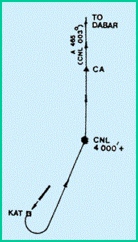
BRAVO DEP (A465 – Northbound)
Turn
left passing KATIVOR. Track to cross "CNL" at or above 4000 ft. and
track 003R to CA and to DABAR
TRANS
ALT. 11,000 ft.
TRANS
LEVEL FL 130
BATIS
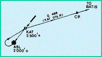
BRAVO DEP (G465 - North-Eastbound)
Climb
straight ahead turn right passing "ASL' to set course over KATNOR 075R.
Cross "ASL" at or above 2000 ft. Cross KATNOR at or above 3500 ft. on
return.
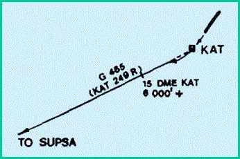
SUPSA
ALFA DEP (G465 - South-Westbound)
Climb
straight ahead. Turn right over KATNOR, track out on 249R. Cross 15 DME at or
above 6000 ft.
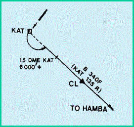
HAMBA
ALFA DEP (13340 F - South-Eastbound)
Turn
left passing KATNOR. Track 135R to HAMBA,. Cross 15 DME at or above 6000 ft.
TRANS
ALT. 11,000 ft.
TRANS
LEVEL FL 130
PDOX
ALFA DEP (R461 - Eastbound)
After
passing KATNOR turn left to track 0830M to intercept KAT 109R to IPDOX via DELTA
(06 56; IN 080 42. 7E) 52 DME/K.AT and cross 10 DME at or above 4000 ft.
IPDOX
BRAVO DEP (R461 - Eastbound)
After
passing KATIVOR turn left to track 1140M (ASL) to intercept KAT 124R and proceed
to intercept and track along RML 10OR to IPDOX. Cross 15 DMEXAT at or above 8000
ft.
TRANS
ALT. 11,000 ft.
TRANS
LEVEL FL 130
BATIS
ALFA DEP (G465 - North-Eastbound)
Passing
KAT/VOR turn left. Track out 053'M to intercept KAT 075R cross 20 DME at or
above 8000 ft.
TRANS
ALT. 11,000 ft.
TRANS
LEVEL FL 130
Above
RAC is an adaptation of AIP Sri
Lanka. The rules and services are subjected to change on regular basis.
![]()