![]()
Flight Plan (FPL)
This
page is intended to explain the contents of a correctly filled in flight plan
and their meaning to relevant personnel. It is a extract of the full information
contained in the Aeronautical Information Publication (AIP) published by the
Civil Aviation Department Sri Lanka. The information is provided here as
guidance, but for the full instructions you should refer to a copy of the latest
AIP.
The,
flight planning is presented according to the VCBI and EGLL route.
Each
aircraft has an official designator, not more than 4 characters, allocated to it
by ICAO and these are published in ICAO Doc 8643.
Completing a Flight Plan
The diagram depicts a actual flight plan filled for the
flight ALK505 which departs from BIA(VCBI) to
London Heathrow (EGKK). The copies of the flight plan should be dispatched to
all the relevant Flight Information Centers(FIC) to make the flight possible at
the given times, routes and levels.
In
addition, for massagers transmitted over the AFTN, there are four characters
added to the indicator to determine the destination agency at the location. A
few of the usual ones are listed below:
ZTZX
- Air Traffic Control - Tower.
ZAZX - Air Traffic Control - Approach.
ZQZX - Area Control Center.
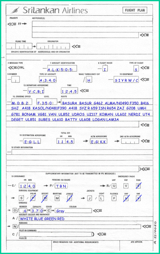
Click on the image for a larger
view
7 - Aircraft Identification Maximum 7 characters
Insert
one of the following:
The
registration marking of the aircraft (ALK505),
8. Flight Rules (1 character)
The
flight rules which the pilot intends to comply
I
= if IFR first
V
= if VFR first
Y
= if IFR first *
Z
= if VFR first *
- specify in item 15 the point or
points at where a change of flight rules is planned.
Type of Flight (1 character)
S
= scheduled services
N
= non-scheduled Air Transport Operations
G
= General aviation
M
= Military
X
= Other than any of the
defined categories above
9. Number and Type of aircraft.
Number
of aircraft
(1 or 2 characters.)
Insert number of aircraft, but only if more than one
Type of aircraft (2 to 4 characters)
The
designator as specified by ICAO,
H
=
Heavy, to indicate an aircraft type with a MTOW of 136000 Kg (300000lb) or more.
M
= Medium, to indicate a MTOW less than 136000
Kg but more than 7000 Kg (15500lb)
L
= Light, to indicate a MTOW of 7000 Kg or less.
10. Equipment.
Radio
Communication, Navigation and Approach Aid equipment.
Preceding the oblique stroke, insert
one letter as follows:
N
= No equipment for the route to be flown is
carried, or the equipment is unserviceable.
S
= Standard
COM/NAV equipment for the route to be flown is carried and serviceable.
Following letters indicate the COM/NAV
equipment available and serviceable:
A - LORAN A
C - LORAN C
D - DME
E - DECCA
F - ADF
H - HF RTF
I - Inertial Navigation
L - ILS
M - Omega
O - VOR
P - Doppler
R - RNAV route equipment
T - TACAN
U - UHF RTF
V - VHF RTF
Z - Other equipment; specify in item
18, preceded by COM/ or NAV/
then, following the oblique stroke, insert one of the following to describe the
serviceable SSR equipment carried:
N - Nil
A - Transponder - mode A - 4096 codes
C - Transponder - mode A - 4096 codes
and mode C
X - Transponder - mode S - without
pressure altitude and without aircraft identification transmission
P - Transponder - mode S - with
pressure altitude but without aircraft identification transmission
I
- Transponder - mode S - without pressure altitude but with aircraft
identification transmission
X - Transponder - mode S - with both pressure altitude and aircraft identification transmission
Departure Aerodrome (4
characters)
Location
Indicator of the departure aerodrome(Every airfield has a Location Indicator like Bandaranaike
International Airport is VCBI).,
or if no location indicator assigned, insert ZZZZ and specify in item 18, the
name of the aerodrome, preceded by DEP/
VCBI
V:
The region.
C: Sri Lanka - The country within the region.
BI:
Bandaranaike International -
the facility within the country.
VCCA
Anuradapura
VCCB
Batticaloa
VCCC
Ratmalana
VCCG
Gal Oya/Amparai
VCCJ
Kankasanturai/Jaffna
VCCT
Tricmalee/China Bay
VCCW
Wirawila
Time(4 characters)
The
estimated departure time
Cruising Speed (maximum 5 characters)
True Airspeed
for the first or whole portion of the flight, in terms of:
·
Kilometres
per hour,
expressed as K followed by 4 figures (e.g. K0350)
·
Knots,
expressed as N, followed by 4 figures (e.g. N0220)
·
Mach
number,
when so prescribed by the appropriate ATS authority to the nearest hundredths of
unit mach, expressed as M followed by 4 figures (e.g. M082)
Level [Cruising] (maximum 5 characters)
planned
cruising level for the first or the whole cruising portion of the route to be flown, in
terms of:
·
Flight
level
expressed as F followed by 3 figures (e.g. F085, F330)
·
Altitude
in hundreds of feet
expressed as A followed by 3 figures, (e.g. A045, A100)
·
*Standard
Metric level in tens of meters expressed as S followed by 4 figures (e.g. S1130)
·
*Altitude
in tens of meters
expressed as M followed by 4 figures (e.g. M0840)
·
or, for VFR flights where the flight is not planned to be flown at a
specific cruising level, the letters VFR.
·
When so prescribed by the appropriate ATS authorities.
Route.
Including
changes of speed, level and/or flight rules. (note that this is an abbreviated
instruction)
Flight along
designated ATS routes
Designator of the first route, or the letters DCT followed by the point of
joining the route
then insert each point at which a change of route, speed, level or flight rules
is planned, followed by the designator of the next route segment.
Flight
outside designated routes
points not normally more than 30 minutes flying time, or 200 nm apart, including
each point where a change of speed, level, track or flight rules is planned.
Destination Aerodrome (4 characters)
Location
indicator of the destination aerodrome
EET
(4
characters)
Total
estimated elapsed time
Alternate aerodromes
Location indicator of not more
than two aerodromes.
18. Other information
0
(zero) if no other information, or, any other necessary information in the
preferred sequence shown below.
·
RFP/
·
EET/
·
RIF/
·
REG/
·
SEL/
·
OPR/
·
STS/
·
TYP/
·
PER/
·
COM/
·
NAV/
·
DEP/
·
DEST/
·
ALTN/
·
RMK/
19. Supplementary Information
This information is not filed with the plan, but is kept at the unit where the plan was filed. In case of emergency the supplementary information will be transmitted to the appropriate rescue agencies.
Endurance
After -E/
a 4 figure group giving the fuel endurance in hours and minutes
Persons
on Board
After -P/ insert the total number of persons (passengers and crew) on board, when required by the appropriate ATS authority.
Emergency
and Survival Equipment
-R/(radio)
·
cross out U if UHF on frequency 243.0MHz is not carried
·
cross out V if VHF on frequency 121.5 MHz is not carried
·
cross out E if emergency location beacon - aircraft (ELBA) is not
available
·
-S/ (Survival Equipment)
·
cross out all indicators if survival equipment is not carried
·
cross out P if polar survival equipment is not carried
·
cross out D if desert survival equipment is not carried
·
cross out M if maritime survival equipment is not carried. Note: this
refers to equipment in addition to the lifejackets listed in the following
section
·
cross out J if Jungle survival equipment is not carried
J/ Jackets
·
cross out all indicators if lifejackets are not carried
·
cross out L if lifejackets are not fitted with lights
·
cross out F if jackets are not equipped with fluorescent
·
cross out U or V or both as in R/ above to indicate radio capability of
jackets, if any.
-D/ (dinghies) (number) cross out
indicators D and C if no dinghies are carried, or insert number of dinghies
carried and;
·
(CAPACITY) insert total capacity, in persons, of all dinghies carried,
and
·
(COVER) cross out indicator C if dinghies are not covered and
·
(COLOUR) insert colour of dinghies if carried.
A/ (AIRCRAFT COLOUR AND MARKINGS)
insert colour of aircraft and significant markings
N/ (REMARKS) cross out indicator N if
no remarks, or indicate any other survival equipment carried and any other
remarks regarding survival equipment.
C/ (PILOT) insert name of pilot in
command
Location
Indicators are a 4 letter code used by the International Civil Aviation
Organization (ICAO) to identify Aerodromes and aeronautical facilities around
the world.
The
code starts by dividing the world into a series of regions, and allocating each
region a letter. Most regions contain several countries, while some regions are
considered large enough to have a letter allocated to a single country,
The
second letter then indicates the country within the region, while the third and
fourth letters are then used to identify the particular facility within the
country. Taking Bandaranaike International identifier as an example, it
decodes as follows:
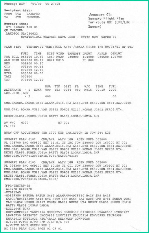
Nowadays
flight plans are computer generated. The information of the fields of FLPs
are stored and updated at regular intervals. A computer generated FLP is
shown below and it contains additional information such as weather and fuel
information.
![]()